Complete NCERT Solutions Guide
Access step-by-step solutions for all NCERT textbook questions

Welcome to the Chapter 7 - Our Country India, Class 6 Social Science - The Earth Our Habitat NCERT Solutions page. Here, we provide detailed question answers for Chapter 7 - Our Country India. The page is designed to help students gain a thorough understanding of the concepts related to natural resources, their classification, and sustainable development.
Our solutions explain each answer in a simple and comprehensive way, making it easier for students to grasp key topics Our Country India and excel in their exams. By going through these Our Country India question answers, you can strengthen your foundation and improve your performance in Class 6 Social Science - The Earth Our Habitat. Whether you’re revising or preparing for tests, this chapter-wise guide will serve as an invaluable resource.
(a) The major physical divisions of India are:
(b) India shares its land boundaries with seven countries, these are:
(c) Narmada and Tapi rivers fall into Arabian Sea.
(d) The delta formed by the Ganga and the Brahmaputra is called Sunderban delta.
(e) 1. There are 28 states and 8 union territories in India.
2. Punjab and Haryana have a common capital Chandigarh.
3. Andhra Pradesh and Telangana have a common capital Hyderabad.
(f) A large number of people lives in Northern Plains because:
(g) Lakshadweep is known as coral Island because these are formed by the deposits of corals.
Coral Islands are formed, when the living polyps die, their skeletons are left. Other polyps grow on the top of the hard skeleton which grows higher and higher.
(a) (i) Shiwaliks
Himadri is the highest range of Himalayas. Himachal is the middle Himalaya and Shiwaliks are the lesser Himalayas or we can say lowest part of Himalayas.
(b) (ii) Western Ghats
Sahyadris or the Western Ghats are the chain of mountains that marks the western edge of the Deccan region.
(c) (ii) India and Sri Lanka
Palk Strait lies between India and Sri Lanka.
(d) (ii) Lakshadweep Islands
Lakshadweep Islands lies in the Arabian Sea. It is one of the Union territories of the India and it is also known as Coral Island.
(e) (i) Aravalli hills
Aravalli range is the oldest mountain range in India. It lies in the northwest part of the country. It passes through three states.
(a) 3.28 million sq.km
The area of India is about 3.28 million sq.km. The north to south extent of India is Kashmir to Kanyakumari and the east to west extent of India is from Arunachal Pradesh to The Rann of Kutch.
(b) Himadri
Himadri are the greater Himalayas. Himadri is the highest mountain range of the Himalayas.
(c) Rajasthan
Rajasthan is the largest state of the India in terms of area.
(d) Arabian
Arabia sea is located at west of the India. Mainly two rivers flows into the Arabian Sea: Narmada and Tapi.
(e) Tropic of Cancer
Tropic of Cancer (23½◦N) runs almost through halfway of the country. It passes usually through 8 states. It divides the India almost into two equal half parts.
Stay updated with our latest educational content and study tips

Interest is one of the most significant ideas in maths and financial calculations. It is very common in banking, loan applications, investments, saving account and competitive exams. Simple Interest and Compound Interest make it easier to find out how much more is earned and/or paid on a principal during the period of time. These Interest … Read more
Read More
In 2026, students, professionals, and job seekers must have a high level of spoken English. Spoken English is a beginner level course to enhance learners’ communication skills in English, their pronunciation, vocabulary, grammar structure and confidence in speaking English fluently. Today, the emphasis of spoken English courses is placed on actual conversations, everyday speech practice … Read more
Read More
Artificial Intelligence (AI) and Machine Learning (ML) are two of the most sought-after technologies in today’s digital era. Although these terms are often used together, they are not the same. Machine Learning is, in fact, a component of Artificial Intelligence that enables systems to learn and enhance on their own, without direct programming. AI is … Read more
Read More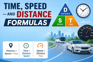
Time, Speed, and Distance are some of the most important concepts in mathematics and aptitude. These are the concepts which are used to calculate the speed of an object, time taken for an object to move and the distance traveled during the motion. Questions from this topic are frequently seen in School Tests, Competitive Tests, … Read more
Read MoreExplore more educational resources to enhance your learning journey

Access step-by-step solutions for all NCERT textbook questions

Practice with latest CBSE sample papers for all classes

Quick reference guide for all important mathematical formulas

Complete multiplication tables with tips and tricks

Discover proven study methods that help students excel in board examinations.

Complete guide to career options and decision-making after completing Class 12.

Learn scientific methods to improve memory and retention for better academic performance.
Join thousands of students who have improved their academic performance with our comprehensive study resources.